


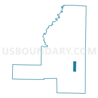
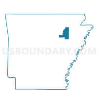
Algoa Voting District, Jackson County, Arkansas
About
Outline

Summary
| Unique Area Identifier | 526771 |
| Name | Algoa Voting District |
| County | Jackson County |
| State | Arkansas |
| Area (square miles) | 4.20 |
| Land Area (square miles) | 4.05 |
| Water Area (square miles) | 0.15 |
| % of Land Area | 96.42 |
| % of Water Area | 3.58 |
| Latitude of the Internal Point | 35.51967600 |
| Longtitude of the Internal Point | -91.12188100 |
Maps

Graphs
Select a template below for downloading or customizing gragh for Algoa Voting District, Jackson County, Arkansas


Neighbors
Neighoring Voting District (by Name) Neighboring Voting District on the Map
- Amagon Voting District, Jackson County, AR
- Beedeville Voting District, Jackson County, AR
- Blackville Voting District, Jackson County, AR
- Remmel Voting District, Jackson County, AR
Top 10 Neighboring County Subdivision (by Population) Neighboring County Subdivision on the Map
- Cow Lake township, Jackson County, AR (377)
- Richwoods township, Jackson County, AR (341)
- Cache township, Jackson County, AR (265)